
Where is Cabo San Lucas located? Cabo San Lucas sits at the absolute southern tip of the Baja California Peninsula in western Mexico. It is officially part of the Mexican state of Baja California Sur. If you grab a map and trace a line roughly 1,000 miles straight south from San Diego, California, you’ll hit the end of the road. Literally. This specific geographic point is where the vast Pacific Ocean crashes directly into the protected, nutrient-rich waters of the Sea of Cortez.
You aren’t just visiting a beach town. You’re standing at the literal edge of the North American continent.
Where Exactly is Cabo San Lucas?
Cabo San Lucas is located at the southernmost tip of the Baja California Peninsula in western Mexico. Geographically, it belongs to the Mexican state of Baja California Sur. The city faces both the Pacific Ocean and the Sea of Cortez, making it a globally unique maritime destination.
People constantly get the geography mixed up. Because “California” is in the state’s name, many first-time visitors mistakenly think Cabo is part of the United States. It isn’t. Baja California Sur is a proud, distinctly Mexican state with its own rich culture, strict environmental protections, and unique desert-meets-ocean climate.
You’ll feel the geography the moment you step off the plane. Dry, dusty desert heat dominates the land. Yet, a cool, salty marine breeze constantly rolls off the water. It’s a striking contrast. Giant Cardón cacti cling to steep, jagged cliffs that drop hundreds of feet directly into sapphire-blue water.
This dramatic topography defines the region. You don’t get flat, endless sandbars here. You get massive granite rock formations jutting violently out of the ocean. The landmass acts as a massive breakwater. This creates distinct micro-climates, heavily influencing where you can swim safely and where the ocean currents are entirely too wild.
Los Cabos vs. Cabo San Lucas: What’s the Difference?
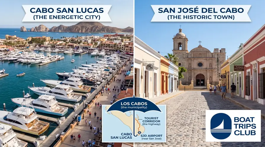
“Los Cabos” is a Mexican municipality that includes two main cities: Cabo San Lucas and San José del Cabo, along with the 20-mile stretch of highway connecting them known as the Tourist Corridor. Cabo San Lucas is just one specific city within the broader Los Cabos region.
Think of Los Cabos as the umbrella term for the entire county. Under that umbrella, you have two sister cities with entirely different personalities.
San José del Cabo sits to the east. It’s older, quieter, and deeply rooted in tradition. You’ll find cobblestone streets, a historic mission church, and high-end art galleries. It’s where you go for a slow-paced evening and a glass of fine tequila.
Cabo San Lucas sits to the west. This is the energetic hub. It holds the main marina, the luxury yachts, the world-famous sportfishing fleets, and the legendary nightlife. If you want action, this is your spot.
Connecting these two distinct towns is a 20-mile stretch of the Transpeninsular Highway called the Tourist Corridor. This coastline features massive, hyper-luxury resorts and championship golf courses carved right into the desert cliffs. Depending on which side of the corridor you choose to stay, your itinerary will shift drastically. That’s why mapping out the best things to do in Cabo San Lucas heavily depends on your specific home base for the week.
How to Get to Cabo San Lucas
Accessibility is a massive reason why this destination exploded in popularity over the last three decades. You don’t need multiple layovers or puddle-jumper planes to get here.
Flying into SJD (Los Cabos International Airport)
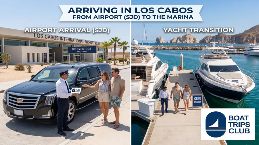
Most travelers arrive by air. You’ll fly into Los Cabos International Airport (airport code: SJD). It’s actually located just north of San José del Cabo.
Flights from the west coast of the US are incredibly short. You’re looking at barely over two hours from Los Angeles or Phoenix. Even flights from major Texas hubs like Dallas or Houston take less than three hours. Once you land, grab your bags and head outside. The drive from the airport down to the Cabo San Lucas marina takes about 45 minutes along the scenic toll road.
Want to check current flight volumes or regional tourism updates? The official Los Cabos Tourism Board regularly publishes data on new direct flight routes opening up globally.
Crossing the Border (Driving & Passports)
Yes, you need a valid passport to fly into Mexico. There are no exceptions for US citizens arriving by air. You can check the exact entry and exit requirements directly through the U.S. Department of State.
Some adventurous travelers still choose to drive. Highway 1, also known as the Transpeninsular Highway, runs the entire 1,000-mile length of the Baja peninsula. It’s a legendary road trip. You’ll cross the border south of San Diego, navigate tight, winding mountain passes, and drive through vast, empty deserts. The drive takes about 24 hours of straight driving time. Most people stretch it over three or four days to surf, camp, and eat fish tacos along the route.
Why Cabo’s Location Makes It a Boating Paradise
The unique position on the map isn’t just an interesting trivia fact. It directly dictates the lifestyle. The ocean dictates everything here.
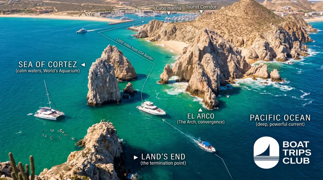
The Sea of Cortez: "The World's Aquarium"
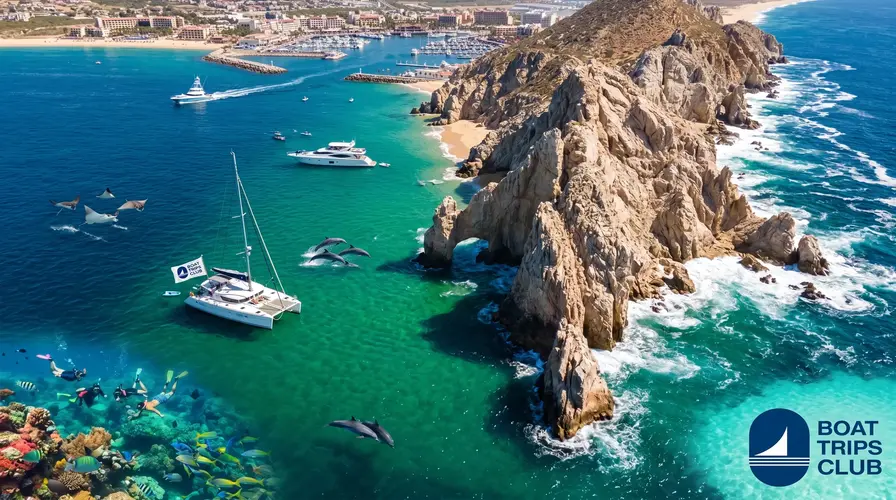
Legendary explorer Jacques Cousteau famously dubbed the Sea of Cortez “the world’s aquarium.” He wasn’t exaggerating. Because the Baja peninsula acts as a massive protective wall against the harsh Pacific currents, the Sea of Cortez remains relatively calm, warm, and highly concentrated with nutrients.
This specific cocktail of warm water and heavy nutrients attracts marine life in staggering numbers. We’re talking resident pods of bottlenose dolphins, migrating humpback whales, sea turtles, and massive schools of mobula rays that routinely leap out of the water. The visibility underwater is often crystal clear. For travelers wanting to get in the water, booking snorkeling tours near Pelican Rock is practically mandatory. You’ll taste the salt on your lips as neon-colored fish dart directly past your mask.
The Deep Sea Drop-Off
Just a few miles right off the Cabo San Lucas coastline, the ocean floor drops drastically. We are talking thousands of feet deep.
This extreme depth so close to shore is rare. It brings cold, nutrient-dense water up from the dark depths to the sunlit surface. This upwelling feeds smaller baitfish, which in turn attract massive apex predators. It’s the exact reason why this specific geographical point is widely considered the marlin fishing capital of the world. You don’t have to run a boat offshore for four hours to find big fish. You are in deep water almost the second you leave the marina.
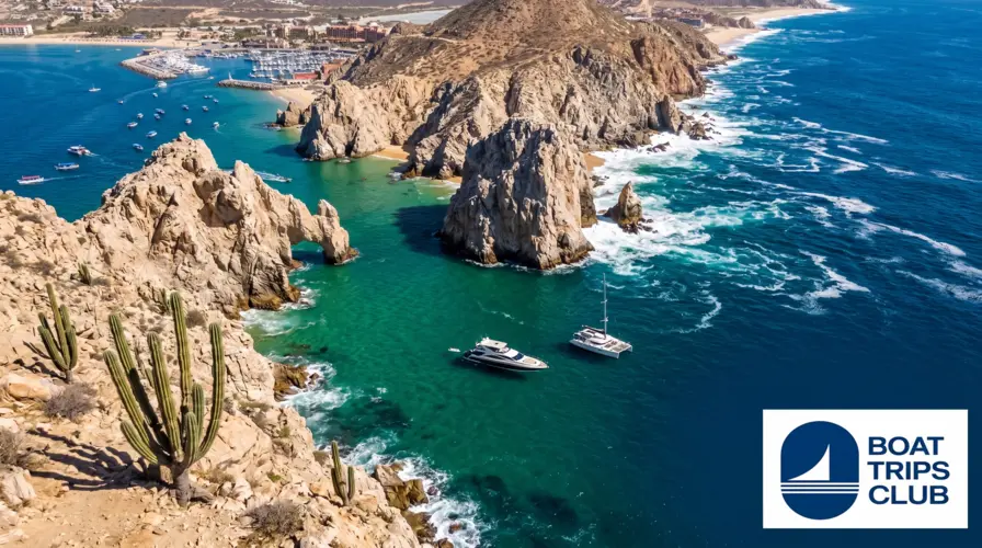
Land’s End and The Arch (El Arco)
You cannot discuss this location without mentioning the rocks. Land’s End is exactly what it sounds like: the jagged, granite termination point of the peninsula. Over millions of years, the relentless crashing of the Pacific Ocean and strong wind carved these rocks into dramatic shapes.
The most famous is El Arco (The Arch). This massive stone archway sits right at the convergence of the two oceans. It’s awe-inspiring up close. You can visually see the chaotic, deep blue Pacific waves fighting against the calmer, emerald-green waters of the Sea of Cortez.
You can’t walk there. You have to experience it from the deck of a boat. Securing a sunset cruise to Land’s End offers the best vantage point. The stark granite glows with violent shades of orange and purple as the sun drops directly into the Pacific horizon.
Navigating the Cabo Marina
The marina is the beating heart of the city. Geographically, it sits in a highly protected, man-made harbor right downtown.
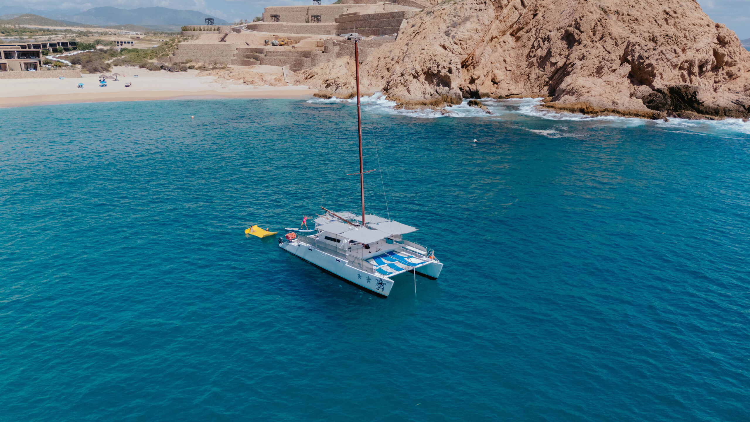
Walking the docks, your senses go into overdrive. You hear the deep rumble of diesel engines warming up before dawn. You smell fresh cut bait mixing with the scent of sunscreen and saltwater. Pelicans aggressively dive for scraps while massive sea lions casually lounge on the swim steps of multi-million dollar yachts.
It gets busy. Very busy. Thousands of tourists shuffle onto packed water taxis every single morning. For those wanting to bypass the chaos and truly experience the region’s geography in total comfort, booking private yacht charters in Los Cabos completely shifts the experience. You dictate the schedule. You control the route. Less planning, more cruising.
Conclusion
Understanding exactly where Cabo San Lucas is located unlocks the secret to why it’s so special. It isn’t just a dot on a map. It’s a geographical anomaly. It’s where harsh deserts meet deep oceans. It’s where massive marine ecosystems collide. Reading about it on a screen is one thing, but feeling the salt spray on your skin as you round Land’s End is entirely different. Ready to stop looking at maps and start exploring the waters yourself? Let’s get you out there.
Frequently Asked Questions (FAQ)
1. Is Cabo San Lucas in the US or Mexico?
It is entirely in Mexico. It is located in the state of Baja California Sur, which sits south of the US state of California.
2. What time zone is Cabo San Lucas in?
The region observes Mountain Standard Time (MST). However, the state of Baja California Sur does not observe daylight saving time, meaning the time difference compared to the US shifts depending on the season.
3. Do I need a passport to go to Cabo?
Yes. All international travelers arriving by air must present a valid passport to clear Mexican customs and immigration at SJD airport.
4. Can you swim in the ocean in Cabo San Lucas?
Yes, but you must know your geography. Beaches facing the Pacific Ocean have massive, dangerous undertows and are strictly off-limits for swimming. Beaches facing the Sea of Cortez (like Medano Beach or Santa Maria Bay) are heavily protected and perfectly safe for swimming.